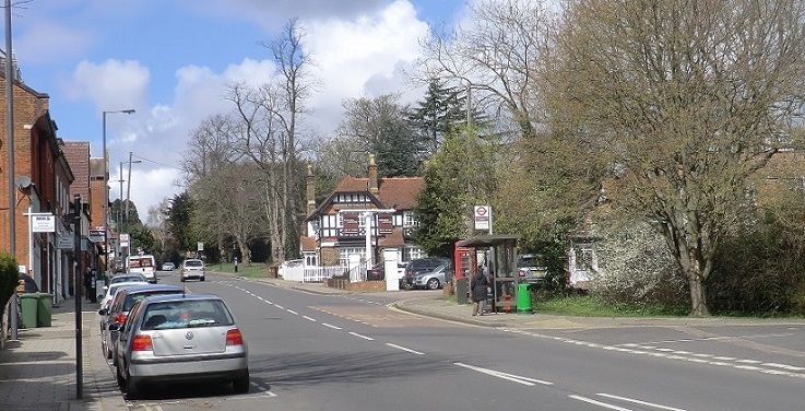
Stanmore Hill is one of the highest points of London, rising sharply from the old village to a height of 152 metres or 499 feet high, which then continues in a northerly direction and crosses the Middlesex - Hertfordshire border
On the 23rd December 1888 the British textile designer William Morris, described the countryside around Stanmore Hill as ” pretty after a fashion, very well wooded, up and down and much beset with gentleman’s houses”.
Well, nearly 150 years later the same can still be said of Stanmore Hill, its slopes are full of many interesting historical buildings some dating back hundreds of years and near the top you will find the wooded area of Stanmore common.
Stanmore Hill became a main road following the creation of a new road to London by the Duke of Chandos to the north of his estate ’Canons’ in 1718 which is now the current London Road. Those travelling from Watford would have descended Stanmore Hill before joining the London Road. After this re-routing, linear settlement developed along Stanmore Hill, Uxbridge Road and around the Little Common area. many of the passing travellers would have stopped at the Abercorn, an 18th century coaching inn developed for the passing travellers.
The Abercorn
The Abercorn was named after the Marquess of Abercorn who acquired the nearby Bentley Priory Estate in 1788. There were stables and outbuildings there for traveller’s horses. Coaches ran from outside the Abercorn to Oxford Street twice a day as early as 1826 and between Stanmore and Holborn from 1803 The Hotel served many travellers on this busy route through Watford to the Midlands, encouraging further settlement on the Hill. Highwaymen were known to have stalked this route since coaches moved slowly up the hill.
The Abercorn’s real claim to fame was its regal connection and was once known as “The Abercorn Arms Royal Hotel” The hotel added the word ’Royal’ to its name to proudly boast about a famous meeting that was held there. It was in this inn on 20 April 1814 that Prince Regent later to be King George IV, the King of Prussia and other European dignitaries met with King Louis XVIII of France. Louis was returning in state to France to reclaim the throne after spending many years in exile in England awaiting the defeat of Napoleon. After a meal at the hotel he left the Abercorn at 15:00, travelling to London. What an extraordinary spectacle it must have been to see one hundred gentlemen on horseback, the trumpeters in their gold lace, and the Royal Horse Guards flanking six royal carriages in a grand procession down Stanmore Hill.
Today Stanmore Hill is in a conservation zone, the zone encompasses a triangle of land with Stanmore Hill to the east and Green lane to the west and much of the land in between. This part of Stanmore was part of the Pynnacles estate.
Pynnacles
The importance of this name to the area is evident as it is still seen in and around Stanmore Hill today. Pynnacles was an old Head Tenement house which originally stood near the corner of Church Road and Stanmore Hill, and was later rebuilt nearer the opposite corner with Green Lane, it was a long building with a classical facade, its land spread further up the hill and included Butts Field. Which was where archery would have been practised. In 1511 Henry VIII decreed all males from the age of seven to seventeen should become proficient with a long bow. The house was at one time occupied by Lt. Colonel Hamilton Tovey-Tennent who gave the field opposite his house, to build the present St. John the evangelist church. Later on the house was occupied by the Wickens sisters, Emily and Katharine who in 1890 donated the money to build Stanmore Cottage hospital on Old Church Lane. Pynnacles lasted until 1930 when it was destroyed by fire. The house was never rebuilt and released 10 acres of land for redevelopment. There is a Pinnacle Place surviving, a listed building on Green Lane.
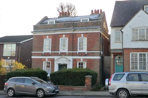
Many of the 19th century houses are still present on either side of the hill and another interesting building is no. 73. Built C1830 it is said to be among the earliest houses built on the hill and has a grade II* listing. It was originally called Loscombe Lodge and later Robin Hill. It stands three storeys high with red brick carefully bonded, stone cornice and string courses, parapet and tile roof. The left flank elevation has first floor Venetian window. A front door case with full cornice, columns and pediment and if you look at the Keystone above the front door it is carved with a bearded face. This building was originally Stanmore’s first police station. The cells for the prisoners were situated below ground and were well protected with iron bars. They are still there and can be seen from the front garden, (remembering of course that it is someone’s house). The other notable point about the property is that it was once the home of Edward Adrian Wilson. Edward was an English physician, polar explorer, Natural historian, painter and ornithologist. He was among the five-man Polar party on that first great Expedition to the South Pole and died alongside Captain Scott on the return journey back to base camp. Cape Wilson in Antarctica is named after him.
At the turn of the 1800’s the house was part of the estate owned by Lord Halsbury, then Lord Chancellor, who also owned a large house called Woodlands, located approximately where the petrol station is today.
In 1898 number 37 was acquired by Hendon Rural District Council as Council Offices with one of its rooms used as the council chamber Another listed structure is the red telephone box outside the Abercorn Arms. This is of K6 design by Sir Giles Gilbert Scott. The K6 (kiosk number six) box was designed in 1935 to commemorate King George V’s silver jubilee
Goodengate
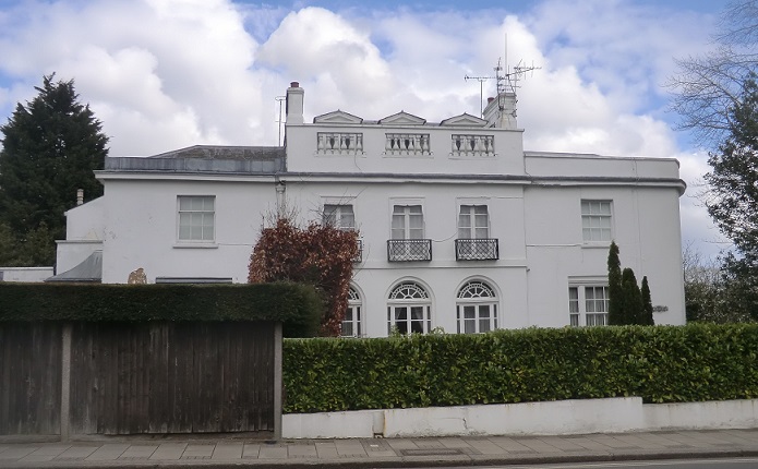
Located at 42-44 Stanmore Hill on the corner of Stangate Gardens, is this spectacular grade II listed building, and a wonderful example of Regency architecture. Goodengate was built around 1812, and known then as Raven Dene. Like many erected in this style has an impressive white painted Stucco façade with a large central porch and an entryway framed by two fluted Doric columns. The house still retains many period features, including an early Regency staircase leading from the communal entrance hall. Another interesting original feature is a skylight on the first-floor landing in the style of Sir John Soane.
As well as a spectacular exterior, the house has been home to a number of renowned residents including George Thomas Doo, trained in Paris he became engraver-in-ordinary to William IV in 1836, and later in 1842 to Queen Victoria.
During World War II the house was requisitioned by the RAF, for members of the Allied Expeditionary Air Force, and the Women’s Auxiliary Air Force who worked in the Filter room at nearby Bentley Priory.
Nulands
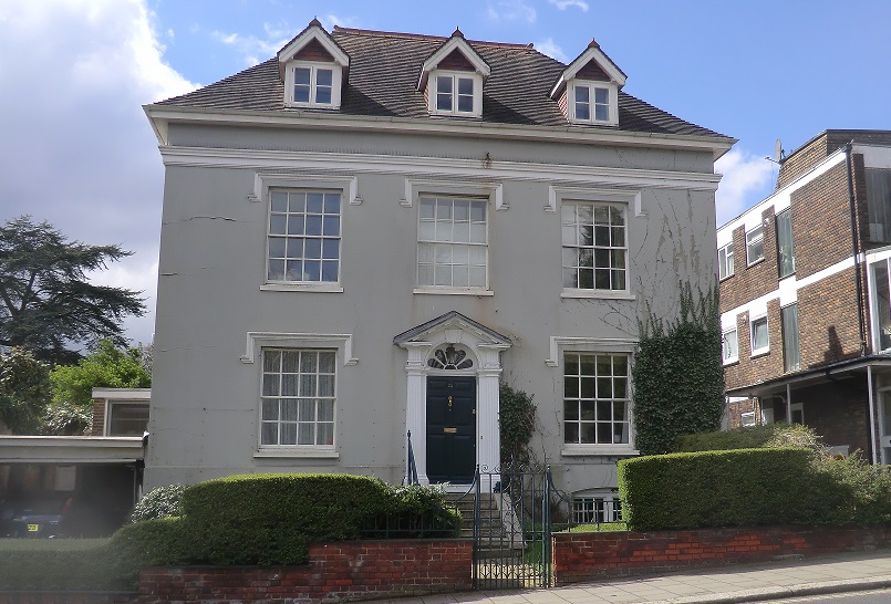
Nulands no. 23 Stanmore Hill. Grade II listed dating to 1720, with later 19th century stucco refacing, is notable for its fine door case and fanlight A total of four storeys including basement and attics, 3 bays wide, one room deep with closet wing. Tudor dripmoulds and cornice tiled roof. Original panelling in all ground and first floor rooms and some chimney pieces. Fine staircase with closed string in panelled enclosure.
Given the importance of the Stanmore Hill route to London, from its 18th century origins, a tightly-packed core developed opposite the Abercorn, towards where Stanmore Hill and Green Lane join one another. The dense development partly reflects that this occurred before enclosure. Retail units developed. The 1851 Census revealed many shops, including specialist shops on Stanmore Hill. This was probably partly due to the large number of gentlemens residences in the area, which also continued to develop along Stanmore Hill. There were 10 bakers, 16 dressmakers, 8 tailors, a watch maker, a historical engraver and a bookseller. Later there was also a Smithy and a Post Office. The Smithy building remains, as does the post office, the latter now offices. There were also two general practitioners. Behind, in close proximity to these retail units, small-scale tightly packed cottages developed along Green Lane.
Land further south from this score, particularly along Green Lane was not developed to any great extent until development of former fields after enclosure which explains their relatively spacious, green character. Indeed, the 1864 OS map shows development did not extend along Green Lane on either side beyond Franklin and Green Lane Cottages. Either side of the road were open fields. Green Lane remained very rural until houses were built in the late 19th/early 20th century. Green Lane as it is today began to develop in the late 19th century when the west side was colonised by four new large residences. These were Culverlands to the north, Benhale, Woodside and Clodiagh. By 1896, the OS shows four houses on the east of Green Lane have replaced fields. By 1911, three extra houses had developed on the east side including Martinsell, Wallon Cottage and Littlecote.
Clutterbucks
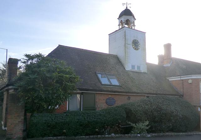
To the north of the junction with Wood Lane are another group of interesting properties, among them are buildings from the former Stanmore brewery, Cluterbucks. The brewery belonged the Clutterbuck family, and had a workforce of thirty. Cluterbucks was taken over by the Cannon Brewery in 1923. The site was then occupied by H. Pattison and co. who manufactured lawn maintenance and golf course equipment. They occupied the site until 1928. Some of the buildings were demolished to make way for housing the remaining buildings like the brew house have been converted into flats. It was during its time as a brewery that man made ponds were dug to supply the brewing process with enough water. The ponds are still there and the entrance to them is over the road next to the cricket ground.
From the 1960s the main form of development was the infilling of large gardens on Green Lane. But relatively higher densities of development remain to the north of the Conservation area where Stanmore Hill and Green Lane join one another, whereas low to medium densities of development remain elsewhere. Fortunately, back land development has been avoided Nowadays the slope from south east to north west along Stanmore Hill and Green Lane provides excellent long distance views and good view towards interesting architectural details or groupings. It allows interesting roofscape views, with chimneys, chimney pots and gables ends or shallow hipped roofs often stepped with the hill. Varied building designs provides interest, but common architectural qualities provide coherence (as outlined within the 'Architectural Qualities' section). The street scene greenery complements buildings helping create the suburban character along with predominance of single-family dwelling houses. There is a linear character to development and in the historic core (towards the top of Stanmore Hill and Green Lane) a tight-knit and enclosed character exists due to the terraced development, whilst the remaining Conservation area has more medium scale development.
